The Dientes de Navarino Circuit is one of the world’s most southerly hikes. This is part 2 of 6 posts about the 5 days I spent hiking the circuit in December 2013 and January 2014. This part covers the first day of the trek from Puerto Williams, up Cerro Bandera, to Laguna Salto.
Part 1: Preparation
Part 2: Laguna Salto
Part 3: Monte Bettinelli and turning back
Part 4: A long day to Laguna Martillo
Part 5: Paso Virginia and Laguna Guanacos
Part 6: The final stretch to Puerto Williams
The official start of the Dientes Circuit is slightly west of Puerto Williams, the only real town on Isla Navarino. I found it easily enough by following the only road out of town and turning left at the large statue of the Virgin Mary. From there it was a gentle walk up to a small area that looked like a car park or picnic area (taking a right where the road splits for a second time).
Key Facts
Location: Patagonia, Chile
Distance: 54 km
Days: 5
Camping: Wild camping
People seen: 4
Difficulty: 4/5
Guidebook: Trekking in the Patagonian Andes
Accommodation: Puerto Williams
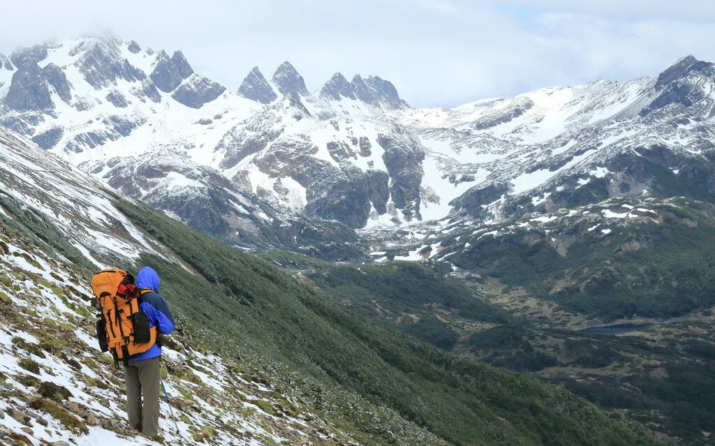
The start of the trail perhaps gave an indication of things to come – the official notice board clearly indicated that the correct route was via the red markers, while markers on the trees, painted with ‘Dientes Circuit’ in blue, indicated a different direction. Guessing that both probably ended up in the same place, I took the right-hand path. This track quickly climbed through the forest, the peace only punctuated by large patches of snow falling from the trees in the morning sun. After about an hour the trail plunged back out into the day light, in a clearing on the hillside just below Cerro Bandera. As I continued multiple trails seemed to converge – perhaps the alternative route indicated by the tree markers?

View over the Beagle Channel to Argentina

The snow moves in as I leave Cerro Bandera
Cerro Bandera is marked by a large flag pole – the purpose of which was apparently just to annoy the Argentines across the water by asserting Chilean authority over this island. Around the period of the Falklands War, Argentina made several other claims to small islands in and around the Beagle Channel. Although no flag waves today, Cerro Bandera marks the highest point of the first day of the Dientes de Navarino trek. It also marked the last sun I would see for some time, as Patagonia’s infamous winds immediately stepped into its place, and visibility dropped significantly. By the time I left Cerro Bandera and was descending the other side, heavy snow was falling and settling quickly on the hilltops. I followed semi-regular cairns that guide hikers across the hill and onto the valley side.

View of Dientes de Navarino and Laguna Robalo
The path contoured the hill for 4-5 hours, always above the tree line and out of its shelter. There is apparently a lower, bad weather route in the valley too, marked on the map – as the wind howled, it occurred to me that this may have been the alternative path marked on the trees at the trail head. When the weather is clear, there are apparently excellent views of the Dientes ahead and various lakes in the valley below. In the snow the scenery was still picturesque, but after 4 or 5 hours I was happy to find the path gradually dropping down towards the lake (Laguna Salto). The final 30 minutes involved an extremely steep drop through a boulder field – I descended very slowly and cautiously, aware of the great ankle-snapping potential these huge rocks offered.
Laguna Salto marks the end of the first day. The area around the lake is heavily used (a popular one night trip is to walk the first day of the Dientes circuit and then return via the valley), and all of the camping locations around the lake were soggy – the only question was, how soggy? Having settled for a slightly less soggy spot on the east side of the lake I settled down, happy that I still had water and didn’t have to take any from this heavily used area. Thankfully this was the only time on the trip when there was more than one other tent at the camp site.
Despite having a map and a compass, as I sat in my tent eating dinner I wondered where the path even continued for day 2. The trail guides all described a climb to the south of the lake, but peering out of the tent door all I could see was vertical looking cliffs…

View from the tent at the end of day 1
Read about day 2 of the Dientes Navarino trek
Map of the Dientes de Navarino circuit hike:
Download this map/kmz file (Created with Garmin eTrex 30 GPS)


