High in the Cordillera Blanca, less than an hour hike from the entrance to the Llananguco gorge, past a turquoise Andean lake and the ancient Keushu ruins, lies the quiet Rajururi gorge. Seeing far fewer visitors than the big-name hiking trails like Laguna 69 and Santa Cruz, this easy 5 hour return trip takes you to within touching distance – and striking distance – of Huandoy’s massive ice falls.

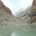
Laguna Keushu, near the start of the Huandoy ice falls hike
Key Facts
Location: Near Huaraz, Peru
Distance: 9.4 km
Days: 1
People seen: 0
Difficulty: 2/5
Accommodation: Llanganuco Mountain Lodge
Guidebook: Cordillera Blanca North 1:100,000 trekking map
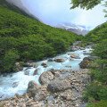
The start of the trail is not exactly peaceful, with loggers on the hill at the entrance to the gorge, and a noisy drainage channel running down from a huge desanding facility just inside. But beyond this the path threw me back into wilderness, with only the sound of streams, insects, and – in the distance – Huandoy’s falling seracs. The path was easy to follow – this is a narrow gorge after all – well trodden and running between two rivers.
Each step gave more expansive views over the Cordillera Negra behind, across the Callejón de Huaylas valley. On either side, the gorge walls rose 1200 metres above the trail, while the 6300 metre peaks of Huandoy stood directly ahead, looming over the ice falls at the end of the trail.

Progressing up the Rajururi gorge, almost at the ice falls

Looking back down the Rajururi gorge towards the Cordillera Negra
The path climbed gently through bush and forest from 3600 metres. With virtually no protection from the baking high altitude sun – this trek requires lots of water, or a means of purifying that available from the streams (even at this altitude there were extensive signs of grazing animals, meaning the water needs to be treated first).
As I reached 3870 metres the trees and the trail suddenly stopped, leaving me standing at the edge of a boulder field. At the opposite end of the boulder field, a small and innocuous wall of white. What I didn’t realise at the time was that this small ice face was – literally – the tip of the iceberg.

Huandoy looms over the ice field below
Climbing further up, I stuck to the grassy hill on the left hand side, using the logic that this area had at least been stable long enough to allow for plant growth. Passing by boulders as big as cars, the noises of falling rock, water, and ice were really loud now, some of them sounding like planes flying directly overhead and reverberating off the gorge walls. Quite a spooky environment, with apparent danger in all directions.
It wasn’t until I reached the top of the hill that – all at once – the true extent of the ice field became apparent. Following the rocky path around, it appeared from nowhere, stretching from the ice face I had seen earlier to the back to the bottom of Huandoy – at least half a kilometre long and 200 metres wide. 500 metres up the Huandoy rock face, the source of it all – large seracs slowly melting in the midday sun. I wondered what one would sound like if it fell, then hoped it wouldn’t.

The massive, active, field of snow and ice that has collected below Huandoy
The ice field itself was constantly, silently moving, with a continuous stream of new material falling down at the back of the valley, and towers forming and toppling before your eyes. It is possible to climb down to touch the ice face itself – but extremely dangerous. The scale is hard to judge, but even a small ice fall could easily be fatal.
As if it emphasize this, as I turned around to get a better photograph I nearly fell over a set of wooden crosses on the hillside – a memorial, it turned out, for a group killed in 2001. As they were collecting ice at the face, new ice fell from the seracs above, killing all 8 of them. A sad, and somewhat unnecessary way to die.

Crosses near the ice field, in memory of those killed by falling seracs
Finding the environment beautiful but somewhat unnerving, I quickly ate my lunch sitting next to the wooden crosses, before retreating to the relative safety of the stunted forest below, following the same track back down to easily complete the round trip in 5 hours.
A possible extension to the trip is to explore further up the gorge, climbing higher towards the serac themselves. To do this you would need to proceed up the grassy hill on the right side of the ice fall, but it is recommended that this is only done with a local guide who knows the area and the current conditions. Needless to say, approaching the seracs up close is foolhardy indeed.
View more photos from Peru, or check out Llanganuco Mountain Lodge, an excellent environmentally friendly lodge right next to the gorge, and at the foot of the Cordillera Blanca.
Map of the Huandoy Ice Falls hike:
Download this map/kmz file (Created with Garmin eTrex 30 GPS)