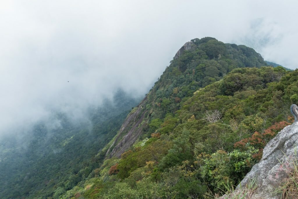
Gunung Ledang, also known as Mount Ophir, sits on the border of Johor and Malacca. Gunung Ledang National Park is about 90 minutes drive from Kuala Lumpur and 2.5 hours from Johor Bahru. The length of the hike means most people stay one night in the area before or after the climb. We stayed the night before at Gunung Ledang Resort – a somewhat shabby place that I wouldn’t rush back to. It is also apparently possible to camp on the summit, though the area is small and exposed.
Key Facts
Location: Johor, Malaysia
Time: 6-8 hours return
People seen: Few
Difficulty: 4/5
Guidebook: The Rough Guide to Malaysia
Organising the hike
Climbing Gunung Ledang requires a guide and must be arranged in advance. As with many National Parks in Malaysia it is quite difficult to track down information online. We found the easiest method was to call the Tourism Johor through the number on their website.
We were quoted 135 MYR per person plus 10 MYR for lunch. Once we arrived at the mountain this mysteriously increased to 153 MYR plus 10 MYR for lunch plus GST plus 100 MYR garbage deposit.
The climb
Our guide set off at break-neck pace up the concrete steps that mark the start of the trail. We were eager to be quick and dozens of people were waiting in the car park to begin the hike. We always prefer a clear trail in front of us! The rude awakening of the steps stopped after about 20 minutes, from where the path continues as a regular trail. The path is shady, surrounded by beautiful, peaceful forest.

The hike is divided into 8 checkpoints. The first two are brutally steep before flattening out and even descending slightly in places.
The section from checkpoint 5 to 6 is known as ‘KFC’ or ‘Killing Fitness Centre’ – a pretty tough ascent up a series of ladders and high steps in the mud. There are several sections where it is necessary to use the fixed ropes to haul yourself up the bare rock face. These sections would be very dangerous in wet conditions, and there is no way to bypass them.

At the top of a rope section in the ‘KFC’
The intensity of the KFC and the ladder climbs gradually reduces and gives way to a small flat false summit. We were shocked by the amount of garbage on the ground here – according to our guide, several decades ago this was the campsite. It served as a stark reminder of how long plastics survive in the environment.
Three or four more ladders brought us to the true summit, at 4187 feet. Happily our lunch of rice and chicken was waiting for us at the top (there is a road almost to the summit on the far side).

The view from the summit is impressive, stretching out across Johor and Malacca states. On a clear day you can see the extent of the beautiful forests of the National Park – and the regimented palm oil plantations beyond.

Even in dry conditions descending the rope sections would be difficult, so we took a different trail down. Much steeper than the ascent, it cut out several checkpoints and rejoined the main track just before checkpoint 3. It is also possible to ascend using this path, though it would be more difficult and less interesting as you would have to descend the same way.
Overall hiking time was 3.5 hours to the top and 2.5 hours down.
Gunung Ledang Map and trail route
Download this map/gpx file (created with Garmin eTrex 30 GPS)


I climbed Mt Ophir in 1965 with several native teacher friends while in the Peace Corps. We set up a makeshift camp the first night with wild boars all around while taking shots of rice wine. Rock climb at summit wasn’t as tough as hacking through trails getting there.
On 23 Sep 2023, I was having cramps and unfortunately one so-called Malaysian Chinese “expert” wearing a cowboy hat and yellow socks eagerly directed me to take the “short cut” route which is the descend route up. He asked me to keep walking and that he would catch up with me. But this never happened so I was walking for half an hour alone till I met another hiker ahead. So I was pretty suspicious about the so-called expert. As mentioned by the author for this article “It is also possible to ascend using this path, though it would be more difficult” (see link below). I totally agree since the KFC route is much easier as the body strength is fairly distributed to the arms using a series of ladder and ropes. On the contrary those directed to this “short cut” route better have very strong legs and fingers since the area is meant for descend and the soil is well worn out raising the steepness of the terrain. Coupled with lack of ladder and ropes you have to grasps the tree branches or roots to ascend. To prove my point, perhaps the next group of hikers can be diverted to this “descend” route to prove that some will not make it to the top. I guess the “expert” have not been updating his terrain knowledge and why many ladies can easily overcome the “difficult” KFC route but I see none attempting to climb the “descend route. Hmmmm….
https://fromheretonowhere.com/asia/malaysia/climbing-gunung-ledang-mount-ophir#comment-3818