This is post 6 of 6 about hiking in Torres del Paine, completing a combination of the ‘W’ circuit and the full ‘O’ circuit in December and January.
- Part 1: Preparing for Torres del Paine
- Part 2: Hiking to Las Torres and the Valle del Silencio (Days 1 and 2)
- Part 3: Hiking to Seron and Dickson campsites (Days 3 and 4)
- Part 4: Hiking to Los Perros, John Gardner Pass, and Las Guardas (Days 5 and 6)
- Part 5: Hiking to Lago Pehoe and Los Cuernos (Days 7 and 8)
- Part 6: Finishing the hike (Day 9)
‘O’ Circuit Key Facts
Location: Patagonia, Chile
Distance: 110 km
Days: 9
Camping: Basic campsites
Difficulty: 3/5
Accommodation: Puerto Natales
Map: Torres del Paine Trekking Map
The final day’s walk from Los Cuernos back to Las Torres is an easy one, offering good views of the back of the Los Cuernos mountains and passing through some quiet little meadows with very little change in elevation. On the very final section the path is flanked by wide fields of bright yellow flowers. Definitely a good way to end a tiring hike.

Yellow flowers lining the path
The buses back to Puerto Natales leave in the morning, meaning I needed to spend a final night in Las Torres campsite. I spent the afternoon lazing on the grass there, watching the ever-changing Patagonia weather over the mountains and reflecting on my trip around them.
Catching an early minibus from the Las Torres campsite to the park headquarters the next morning, there was plenty of time to get great views back over the torres, and to see guanaco running in the nearby hills while I waited for the bus.

Guanaco near the park entrance, having just taken a dip
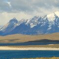
After a short stay at Erratic Rock 2 in Puerto Natales I took Navimag ferry up to Puerto Montt. This ferry is an excellent option, taking three days to travel though the Seno Ultima Esperanza (Last Hope Sound) and Chilean fjords, viewing glaciers and snow-capped mountains on the way. With little to do except admire the landscape, it is a great way to relax and reflect after a long hike.

The sun sets as the Navimag ferry leaves Puerto Natales to start the journey home

Cruising home on the Navimag ferry from Puerto Natales to Puerto Montt
Map of the Torres del Paine ‘O’ circuit hike (days 7, 8, and 9):

Download this kml/kmz file