Location: Patagonia, Chile Distance: 110 km Days: 9 Camping: Basic campsites Difficulty: 3/5 Accommodation: Erratic Rock 2 Map:Torres del Paine Trekking Map
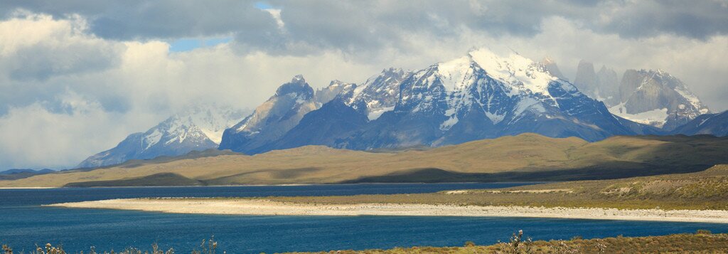
The ‘O’ circuit combines the two main hiking routes in Chile’s Torres del Paine National Park. The ‘W’ trek trail visits the famous towers (the Torres), the French valley, and Grey Glacier in 3-5 days and is the most popular of the options, being closer to civilization and having modern cabins, camp sites, access to basic food supplies, and even a hotel. The popularity of the ‘W’ route means that the hiking trails here can get quite busy.
The alternative route is the longer full circuit, which passes behind the main massif, circling around the back of the park, emerging at Grey Glacier, then circling along the bottom of the ‘W’, taking around 10 days in total. The full circuit, though still equipped with rangers’ posts at the camp sites, is much more remote and less heavily visited. While walking I only saw 3 other people in the entire back section, and that was in the peak season of December and January. Towards the end of the full circuit you cross the southern part of the ‘W’ trail, so you do not miss any of the park by taking this option.
Torres del Paine is easily accessed by bus from Puerto Natales (Erratic Rock 2 is a nice place to stay there). From the national park headquarters at Laguna Amarga smaller minibuses take visitors to the area near Hotel Las Torres, which has modern accommodation for those who don’t feel like camping. For those who do prefer a tent, there is a beautiful grassy area here with a modern shower and toilet block.
Torres del Paine park entrance
My plan for the first day was to climb up the Valle de Ascencio towards the famous Torres del Paine and camp at Campamento Torres, leaving a 45 minute walk from the camp site to the viewpoint, which I planned to visit at sunrise in hope of setting the towers without cloud. The walk up the valley took between 3 to 4 hours with all my gear and food for ten days, and I quickly learnt that the points marked on the map as ‘windy’ really are extremely windy – several times on the way down the hikers on the path had to stop or even sit down to avoid being blown towards (over!) the edge of the path.
Valle Ascencio
The Campamento Torres campsite is a nice, relatively peaceful campsite in the woods just off the path to the main summit. It has a supply of water running straight from higher up the mountain (I didn’t drink this water untreated because of the number of people around on the paths further up, but I did drink the water in other, less busy, parts of the park without problem).
Campamento Torres
From Campamento Torres the main hike is the 45 minute climb to the Los Torres viewpoint, which must surely be one of the most famous views in Chile, with the park’s three rock towers standing over a small glacial lake. The towers – imaginatively named North, Central, and South – stand over 8000 feet tall (North is actually 7400 feet), dominating the surround landscape. They were, of course, partially hidden behind cloud when I arrived – as they are for the large part of the time. The best chance of seeing them unobstructed is at dawn. Nevertheless they are a spectacular sight and, at the very beginning or end of the day the viewpoint is relatively quiet a peaceful once the hordes of tourists have left.
Torres del Paine
Torres del Paine
Andean Fox
Another relatively easy sidetrip from Campamento Torres is the path up the Valle Ascencio, through beautiful Magallenic forest towards Campamento Japones and into the Valle del Silencio. I never like to leave a trail – especially a rarely visited one – untried, so after leaving the Torres I headed out on this trail. It is a particular peaceful trail, just below the tree line and following a gentle river. The path jumps between patches of protective Magellenic forest and exposed areas of morraine which offer spectacular views of the surrounding mountains. Of all the tails I took in Torres del Paine, this was the most peaceful – I saw nobody at all the entire time.
Magellanic forest
Valle del Silencio
Valle del Silencio
Valle del Silencio waterfall
Just before the end of the Valle Ascencio, where is meets the Valle del Silencio, is a small run-down hut known as Campamento Japones (Japanese Camp). This is apparently used as a base for climbers hoping to venture further into valley, but was eerily empty when I came upon it. I quickly moved on to where the path leaves the tree line and the Valle del Silencio comes into view. The valley is almost completely filled with a rocky moraine that curves back behind the Torres del Paine, right into the heart of the park.
Valle del Silencio
To continue up the valley was tempting, making my own way now the path had vanished on the rocky surface, but the high winds and the late hour meant it was more sensible to return to the campsite, pack up, and return to Las Torres ready to start the ‘O’ circuit hike tomorrow. I really wish I had carried my tent and found a wild camping somewhere in this valley though…
As it turned out it was probably a wise decision to turn back as the winds were now picky up incredible speeds this high up the mountain. At one point a waterfall appeared to stop and then change direction as the wind carried its water back up the mountainside. On the descent several groups of walkers climbing up to the Torres were clinging desperately to tree roots to avoid being blown over as they made their way up, with others deciding to turn around.
Back down at Las Torres, the base of the ‘W’, things were much calmer, and the campsite was virtually empty. With beautiful views towards the Torres del Paine and Paine Grande I spent the rest of the afternoon watching the remarkable Patagonian weather pass over the mountains.
The Torres del Paine 'O' circuit combines the National Park's highlights - including the famous towers - with peaceful back-country hiking and camping.