Angels Landing is one of the most popular trails in Zion National Park, famous for its vertigo-inducing drops and minimal safety features. Although not a physically demanding hike – even the hike up to the massif itself is relatively short – it demands a strong head for heights and should definitely not be attempted by anybody with a fear of such.
Key Facts
Location:Zion National Park, Utah, US
Distance: 7.6 km
Time: 4 hours
People seen: Dozens
Difficulty: 2/5
Guide: Zion National Park
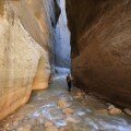
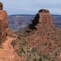
The Angels landing trails starts at the Grotto stop for the free national park shuttle bus, cross a small river and then zig-zags quite steeply up the mountain side for a few kilometres, through a section known as Walter’s Wiggles. This section is easily achievable by any reasonably fit person. However, Angels Landing ‘proper’ – the section most photographed, featuring narrow paths and incredible drop-offs, is really the final half mile. From Scout Lookout – a rock plateau that is the recommended turnaround point for those unable or unwilling to tackle the trail, the path climbs steeply and constantly, cut directly into the rock face. Here, the narrow finger of the Angel’s Landing massif protrudes from the surrounding rock, with the trail cut directly into it. Rarely is the path wider than two metres, and more often it is much less than that. Cliffs of over 400 metres on both sides are a constant reminder of the potential price of an accident.

On the edge
The trail does feature steel chains to aid hikers, but these should not be fully relied upon – although they appear strong, they only exist on one side of the path, and even then, only in certain places.
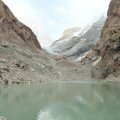
There are a couple of slightly wider or less exposed sections along the trail, and I definitely recommend stopping there to admire the view of Zion canyon (both across it and down into it!) Far below, the national park shuttle buses look tiny as the ply the road up and down Zion canyon.

Looking down at the road a long, long way below
The ‘summit’ plateau at the end of the hike is a relatively wide, off-camber rock area big enough to sit, take a rest, and admire the sensational views along Zion Canyon – and the ridge you have just walked along.

Looking back along the trail from the top of Angels Landing

The slightly wider summit area at the end of the ridge
Angels Landing definitely has the potential to be very dangerous. When wet, or when rain is threatened, it obviously should not be attempted. Numerous sections are highly exposed and any fall would be fatal. Being on the ridge in a lightning storm would also be unpleasant. According to the NPS five people have died on Angels Landing in accidents since the park’s establishment in 1919. Personally I think that is a pretty good record. There is some debate about whether the National Park Service should put stronger warnings on the trail, or even introduce a quota system in a attempt to make it safer. I really hope they don’t. One look at the Angels Landing trail tells you it is narrow and dangerous – you can see it is potentially dangerous. From Scout’s Lookout you can see that there are cliffs either side of the path and that there is only a single chain link for safety. These should, really, be sufficient warning to anybody attempting the hike.
Map of the Angels Landing hike:
Download this map/kmz file (Created with Garmin eTrex 30 GPS)